Stations

Stations

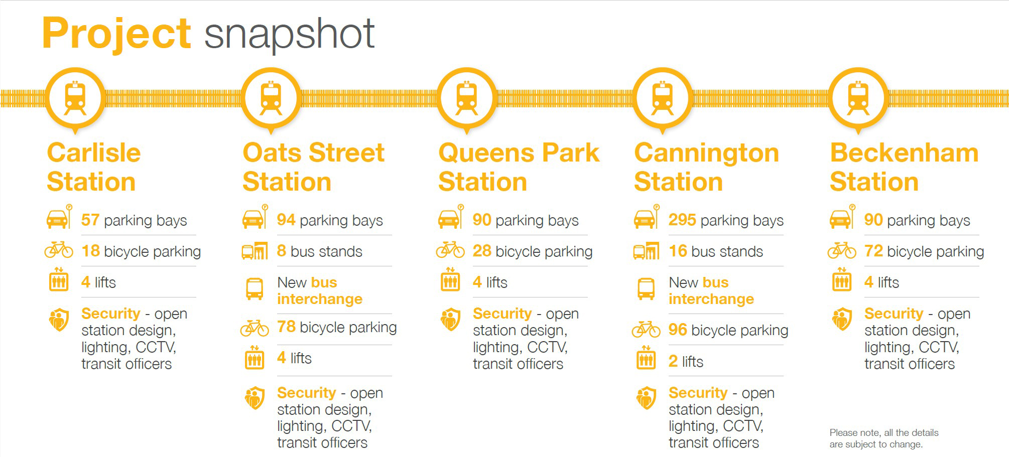
The Victoria Park-Canning Level Crossing Removal is a city-shaping project that will deliver Perth’s first major elevated rail solution. The project includes rebuilding five elevated stations at Carlisle, Oats Street, Queens Park, Cannington and Beckenham.


Long Park

METRONET is transforming around six hectares of former rail land into Long Park - a vibrant public space with flexible and enjoyable recreational spaces and parkland for the community. 

View the Long Park map to learn more and read about each new activation area. 

Through extensive consultation with community and stakeholders, Long Park has been shaped to reflect local priorities. Read more about the community priorities for public spaces

Long Park will feature 14 new activation areas including:

  • four new playgrounds
  • two nature trail/play spaces
  • two youth plazas including basketball, futsal and netball courts
  • three skate zones
  • two fitness parks with exercise equipments
  • two dog parks
  • extensive path network for bike riding and walking
  • new spaces for pop-up cafes and community events.


Carlisle Station

Carlisle Station will be rebuilt closer to the Mint-Archer Street precinct with a welcoming forecourt as part of the elevated rail solution to remove the Mint Street level crossing. 

The new station will provide improved pedestrian connections and passenger facilities, including longer platforms.

The Noongar place name for Carlisle Station is Djoorolup and the narrative is ‘Place of the Jarrah trees’.

Read more about the new Carlisle Station and public space.


Public Spaces

*map not to scale.

View the Long Park map to learn more and read about each new activation area.


Mungyte Place

A multi-generational space with a range of activities including a playground, bocce court, performance lawn, BBQ area, exercise equipment and integrated artworks. 


Banksia Discovery Trail

A series of informal pathways and clearings woven through native planting to create an integrated nature play trail that tells the story of the banksia.


Fitness Park

Fitness Park is an outdoor gym for programmed and individual exercise, providing accessible fitness equipment for circuit-style training.


Public Art

View the public art map here.

Oats Street Station

Oats Street Station will be rebuilt as an elevated station with entrances at both ends to better connect to the surrounding area, allowing the removal of Oats Street level crossing.

The new station will be built further south closer to Welshpool Road to provide an alternative option to service the Welshpool area, with the closure of Welshpool Station. 

The Noongar place name for Oats Street Station is Mundee and the narrative is ‘Leader of the Djooral Kalla clan’.

Read more about the new Oats Street Station and public space.


Public spaces

Oats Street precinct public space layout

View the Long Park map to learn more and read about each new activation area.


Puggle Playground

A nature playground that tells the story of the echidna through integrated First Nations artworks. Play opportunities include climbing structures, swings, tunnels and balance walks.


Oats Street Youth Plaza

A youth plaza incorporating a 3 x 3 basketball court and a low-level hybrid skate park suitable for all skill levels.

Read more about the public space: https://www.metronet.wa.gov.au/projects/level-crossing-removal#public-space.


Public Art

View the public art map here.


Queens Park Station

The new elevated Queens Park Station will be rebuilt closer to Hamilton Street with a welcoming forecourt as part of the elevated rail solution allowing the removal of level crossings at Hamilton and Wharf streets.

The new station will be relocated slightly north for improved accessibility and connectivity.

The Noongar place name for Queens Park Station is Boree Boree and the narrative is ‘The large flat plain and land of Joobaitch’.

Read more about the new Queens Park Station and public space.


Public spaces

View the Long Park map to learn more and read about each new activation area.


Railway Dog Park

A dog exercise area with two fenced zones featuring airlock gates, seating, informal agility elements and a drinking fountain. 


Water HQ

A central gathering space and outdoor classroom for use by surrounding schools. Integrated artworks and interpretive signage tell the story of water across the site.


Youran Playspace

A small seating and play space focusing on integrated First Nations artworks representing the bobtail lizard.


Queens Park Community Hub

An inviting, flexible space nestled in the parklands. Located between Queens Park Station and the Railyard Playground, the wide open lawns, seating, BBQs and picnic tables provide opportunities for everyday use and a wide variety of events.


Public Art

View the public art map here.


Statement artwork - located at the centre of the 7km line, a sculpture will feature at Queens Park Station and will celebrate the location as a place for Noongar themes of truth-telling and healing, and a historical site of dislocation and displacement. 


Cannington Station

Cannington Station will be rebuilt as an elevated station in the same location allowing the removal of Wharf Street and William Street level crossing.

The new station will also have a bus interchange with 16 bus stands.

The Noongar place name for Cannington Station is Karakaliny and the narrative is ‘Place of the red cockatoo’.

Read more about the new Cannington Station and public space


Public spaces

*map not to scale

View the Long Park map to learn more and read about each new activation area.


Cannington Youth Plaza

A youth plaza incorporating a full-size futsal and basketball court, a netball court and a hybrid skate park.


Railyard Playground

A playground that draws on the rich history of the train line with a focus on the timber transported from the south-west. Play opportunities include climbing structures, and an interpretive locomotive play element with slide and water play.


Public Art

View the public art map here.

Beckenham Station

The new elevated Beckenham Station will be rebuilt with a forecourt opening onto the plaza precinct with better connectivity whilst removing the William Street level crossing.

The new station will be rebuilt as an elevated station providing space for recreation while improving accessibility and connectivity.

The Noongar place name for Beckenham Station is Djarlgarra and the narrative is ‘Place of abundance (Canning River)’.

Read more about the new Beckenham Station and public space.


Public spaces

View the Long Park map to learn more and read about each new activation area.


Basin Park

A small park with seating around the Woodlupine Book designed to enhance the existing drain and create a vegetated basin.


Beckenham Dog Park

A dog exercise area with seating.


Wheels Park

A community space for activities including a bike pump track, and a wheels loop with integrated obstacles for skateboards, scooters and skates.


Public Art

View the public art map here.

For further information on train and bus services, head to the Transperth website.

Back To Top